
Ugborough
dot com
Ugborough Village and Parish
History and Archive Photographs.
After the Romans left, the South Hams was a thinly populated part of the Celtic Kingdom of Dumnonia. Saxons, arriving by sea from Sussex and by land from Wessex, had by the 6th Century effectively occupied and were farming all the lands to the Tamar. Few Celtic place-names have survived in our area. Two local exceptions are Penquit (cf. Welsh pen ‘head, end’ and coed ‘wood’) and the Glazebrook (cf. Welsh glas ‘blue, green’
The name Ugborough derives from 'Ugga's fortified place'. Recorded as 'Ulcebrg' in Domesday 1086, there were five Domesday Manors plus two smaller ones, and three post-Domesday Manors.
Until the 19th century, Ugborough Parish was the largest in the South Hams, but over the years boundary changes have reduced it. The present Parish boundary extends out onto the moors to Redlake where china clay was extracted intermittently between 1913 and 1932.
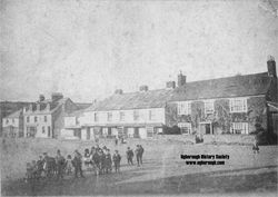
The Square
Sheep and cattle markets were held monthly in the village Square in Ugborough. The first Annual Fair took place on 25th May 1752. It is still held regularly but now takes place on the second Saturday in July.
The ownership of the square was disputed in 1848 when the Church built the flight of steps in front of the Church Wall. The Courts declared the land to belong to the Manor of Ugborough, at that time in the possession of the Carew family. The building of the steps was accepted on payment of a token.
In 1976 Devon County Council resurfaced the square making out the parking places, cobbling the pavements, replacing street lights with lanterns, rebuilding the bus shelter and declared the Square and surrounding area a Conservation Area. The trees were donated by various organisations and individuals.
The Conduit
The Conduit in the Square was renovated to celebrate Queen Victoria's Golden Jubilee in 1887 and served as the first piped water supply to the village. It contained a large cistern filled with water piped from a spring above the School. Water was conveyed to various sites in the village. The Conduit was in use until 1942. Prize money awarded through the Best Kept Village competition has been used to refurbish the conduit and also to provide the Parish Council noticeboard in the Square.
Donkey Lane
Donkey Lane leads down from the Church towards the new burial ground. It was originally a Church path but now belongs to the Parish.
Photographs
Ugborough History Group has a large archive of photographs from the last 100 years - are selection are on view here and copies are available on request. Please email for details here... A selection is on view here.
 |  |  |  |  |  |  |  |
|---|---|---|---|---|---|---|---|
 |  |  |